
An Oliver Travel Trailers’ Journey To The Channeled Scablands
By: Frank McMichael, Hull No.101
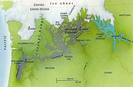
The picture below is a depiction of the western portion of the northern ice cap as it was slowly receding from the warming that started approximately 15,000 years ago. The eastern ice cap had descended further south than the western portion of the ice cap. As indicated in my first ‘part 1 of the series’, the eastern ice cap was as far south as Ohio. Likely the warming effect of the Pacific Ocean curtailed the southern movement of the western ice cap. It is also interesting to note that Alaska and the North Pole were not under the ice cap. Also, keep in mind this is a depiction of the melt time not the extent of the maximum range of the ice cap.
The image below indicates where the Scablands are and where the geologists believed was the likely source of the water like Glacial Lake Missoula that was created by an Ice Dam. It is believed that once the Ice Dam broke, the water flowed from the Lake to create the Scablands. This theory has several problems, one is that not enough water could be held back by an ice dam to cause the erosion effects that occurred. In order to explain this differential, the current theory is that this happened as many as 80-90 times over thousands of year.
Along with the belief that the glacial lake could not contain a sufficient volume of water to create the scouring effect and the deep canyons that can be seen today the second problem is that multiple ice dam formations could not have happened. It is claimed that it makes little sense that if the climate was warming that ice dams would continue to form multiple times in the same general location while holding back meltwater from the ice cap. If the ice cap was melting, the likelihood of multiple ice dams forming at the same time seems to be low. After all, the ice dam was part of the ice cap so it is not likely to freeze and form again while other parts are melting.
J Harlen Brentz Ph.D., the first geologist to study the erosion effects of the Scablands initially thought that it was formed by a one-off event but he was unable to indicate what the cause and source of the water could be. It took him forty years to convince other geologists that the erosion effects in the Scablands were caused by water. Under pressure from his peers, who believed in geologic incrementalism or uniformitarianism rather than singular catastrophic causal events, (known as catastrophism), he eventually capitulated to their belief that because such a massive flood event had never been observed before, therefore it could not have occurred in the past. Today, because of awareness of a past meteor event that killed the dinosaurs there is a larger understanding about a possibility of a singular cause but still many geologists continue to believe that there were many meltwater floods.
As indicated, others believe another explanation is required over repetitious or multiple flood events. Given other indicators of change that occurred in the same time period, such as the disappearance of the megafauna of North America, (e.g. Wooly and Columbia mammoths, giant elk, giant sloth, sabretooth tigers, dire wolves and many others). During this time, 137 species simultaneously disappeared along with the Clovis culture humans who lived south of the continental ice sheet in the unglaciated portion of North America. Along with the disappearance of species in North America, events and circumstances all over the world indicated that something much more catastrophic occurred during this time.
Their theory is that a comet, asteroid or solar flare struck the ice cap 12,800 years ago, instantly flash melting it or a portion of it, causing massive flooding and rapid sea level rise of 300-400 feet. The moisture upwelling into the atmosphere caused by this impact upon the ice cap created major rain events, a rapid sea level of nearly 400 feet and massive flooding worldwide.
The rapid sea level rise and the tremendous rain events created havoc and distress worldwide which were remembered and transmitted orally via stories that became legends and eventually myths. The biblical story of Noah and other cultural myths about flooding found in other locations worldwide may have its origins in this event. The Sumerians who lived four thousand years before the time of the writing of the Bible described such a flooding. They had stories written on clay tablets of a massive flood that affected the whole world. The Sumerian time was 6,000 to 7,000 years after the time of this event which is thought to have occurred 12,800 years ago.
As in many other issues in geology, contention over such an event can be argued and discussed over a long time before consensus occurs. Witness the contention about the meteor impact theory regarding the death of the dinosaurs. Some are still arguing that the death of the dinosaurs was caused by massive volcanic activity, not a meteor impact.
Regardless of who may be right, the Scablands exist and they are fascinating to visit. I traveled about a large part of the Scablands but not all by a long shot. There were four major geological features formed by the flood, remnants that can be readily observed today, that I wanted to see: Wallula Gap; Palouse Falls; Pothole Coulee and Dry Falls.
My trip to Wallula Gap and Palouse Falls, I will mention here. Dry Falls and Pothole Coulee will have their own articles.
Wallula Gap
Wallula Gap was to be my first way-station for my travels across the Channeled Scablands.
Starting from Umatilla, Oregon, SR 730 east travels through high basalt cliffs on the south side of the road and the Columbia River on the north side. Although I did once get the tourist go home signal, compared to other roads in this part of the world it is less traveled, so this gives a traveler an opportunity to drive slowly and look at the terrain and the river. My objective was to pass through the Wallula Gap. As this was the gateway to the Scablands, I was hoping to get a sense of scale and proportion of this flood by viewing the Gap.
During the ice age flood, the Wallula Gap was the choke point for the flood to reach the Columbia River and then the Ocean. All the Scabland drainage passed through here. The amount of water flow was so massive that at its peak, it was over 1,000 feet above the present day Columbia River. The width and depth of the Columbia River Gorge testifies to that height as it was cut by this Flood or floods.
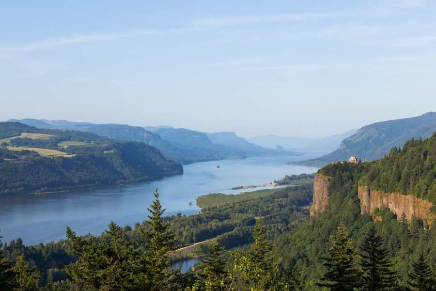
As can be seen from the above map, the Gap was the narrowest part of the Columbia River Gorge during the ice age floods. It is still true today, it is about two miles wide. West of this location the Columbia River Gorge is much wider. The widest part of the Gorge is about five miles, the average width of the Gorge is three miles. The average height of the Gorge cliffs is 1,500 to 3,000 feet. The maximum elevation of the Gorge walls is 4,000 feet. The average width today of the Columbia River in the Gorge is one mile. While I did not go there on this trip, I have been to the Vista House observatory in the below photo several times, it provides a view of the Gorge not equaled anywhere else.
The ice age flood waters were so extensive that it spread out more than a 100 miles wide over thousands of square miles, above the Gap forming the Channeled Scablands. The Gap of maybe two miles wide restrained the drainage of a hundred miles wide flood flow. Visualize a small culvert trying to drain a large flood area and you will have the concept. Although it is amazing to think that a two mile wide gap was small enough to back water like that small culvert.
The backed up water seeking other outlets to the Columbia did find them but all were above the Gap, so in the end all of the water had to find its way through the Gap. I will be telling you about one such outlet into the Columbia River known as the Pothole Coulee in a future article.
The backed up water, because of the Gap, created tremendous pressure as the water surged through the Gap. Once the water exited the Gap it was under such hydraulic pressure that it scoured what is now the 80-90 mile long Columbia River Gorge.
Still today, there is a 150 to 200 foot deep channel in the Pacific Ocean that reflects the scouring effect of this flood.
Keeping in mind that the Oceans of that time were approximately 400 feet lower than present day, it is not hard to understand that the effect went on for miles past what is present day Astoria and the current mouth of the river. Indeed, Portland is built on the backed up detritus from this flood of floods.
The Wallula Gap is noteworthy for its effect on the ice age flood but because of its size it is difficult to get a cohesive view and thus is not as dramatic or spectacular to view as some other locations, although others may differ with my opinion. However, I found this area to be extremely interesting in that it helped to understand something about a flood that was more than ten times larger than the combined flow of all the current rivers in the world today.
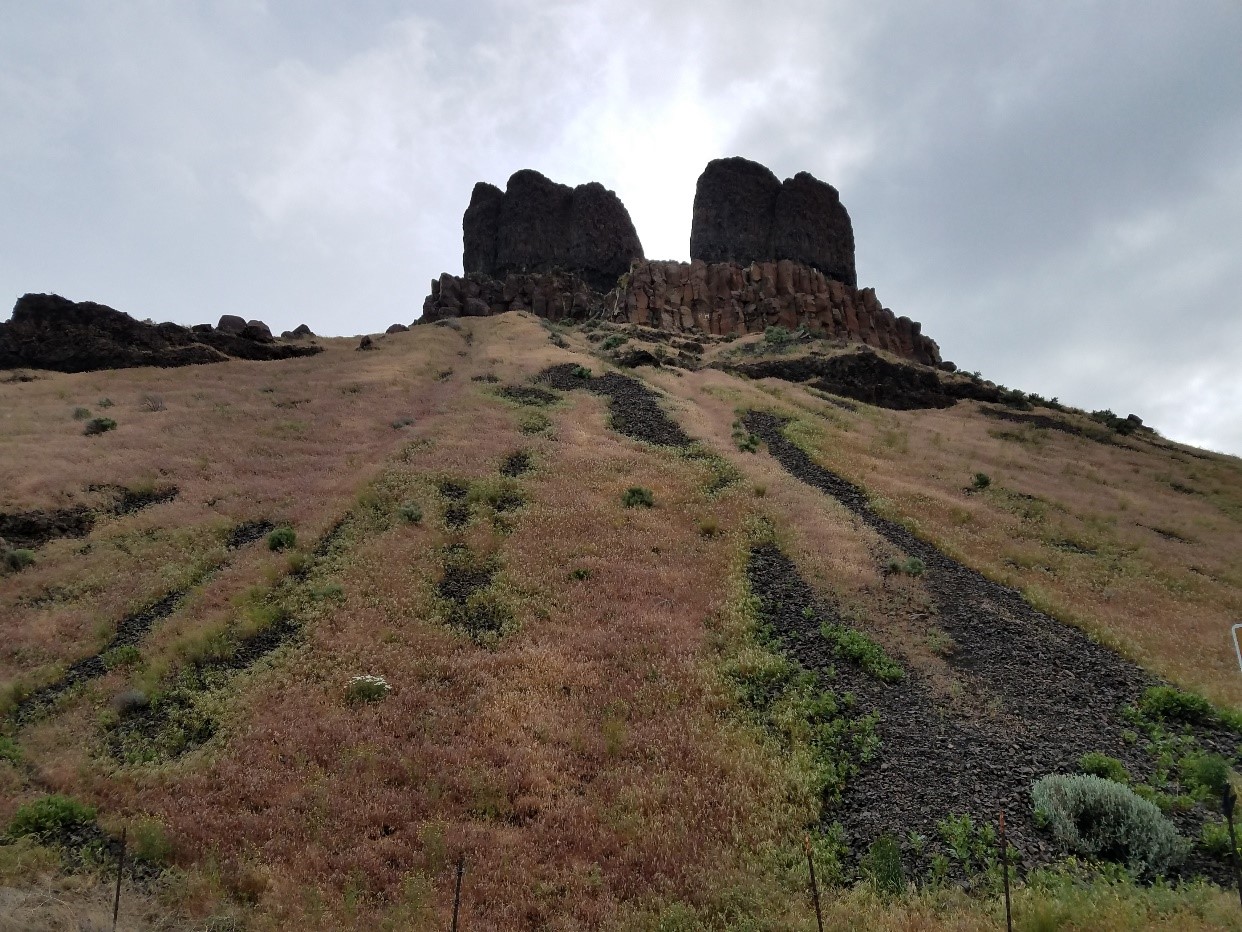
One of the interesting terrain features along SR 730 is this two towered basalt monolith that somehow escaped the full impact of the flood. The towers are about 100 feet high. Local Indians named them the Two Sisters. The Indian Legend is that Coyote became jealous of his two wives and turned them to stone, so they sit there today in testimony of his jealousness. Geologists have another opinion about this formation but it is still called the Two Sisters.
The Willamette Valley is the central valley in Oregon. It lies between the coastal mountains to the West and the Cascade Mountains to the east. This valley is similar to California’s Central Valley as to how it is located. During the peak of the flood, the Willamette Valley filled with water and silt (see map). The left behind silt provides the basis of some of the best farmland in the US, if not the World. There are erratic boulders carried by the flood as far south as Eugene Oregon which is about 200 miles from the present day Columbia River.
Palouse Falls
The Scablands are so large and so complex like a maze that one visit cannot bring it all together. To fully understand the Scablands and to fully appreciate the features that were caused by the flood and left behind after the flood, one must see and walk them. Not all can be seen as private lands and the works of man make them unavailable or they have become obscure.
Some features like Wallula Gap, can be generally observed but the scale is so large that it is impossible to fully comprehend it or photograph it except possibly with the use of a photographic drone. Others like Palouse Falls can be reached, photographed and be somewhat understood because it is at a scale that fits more the human perspective.
The Palouse River empties into the Snake River. The Palouse River Canyon and the Palouse Falls are not very distant from where this occurs. The Snake, rises in the mountains east of Yellowstone and makes its way north until it, in turn, empties into the Columbia River.
Palouse Falls is considered the “crown jewel” of the Palouse River. The falls drops 200 feet over what is called a “recessional cataract” into a deep plunge pool.
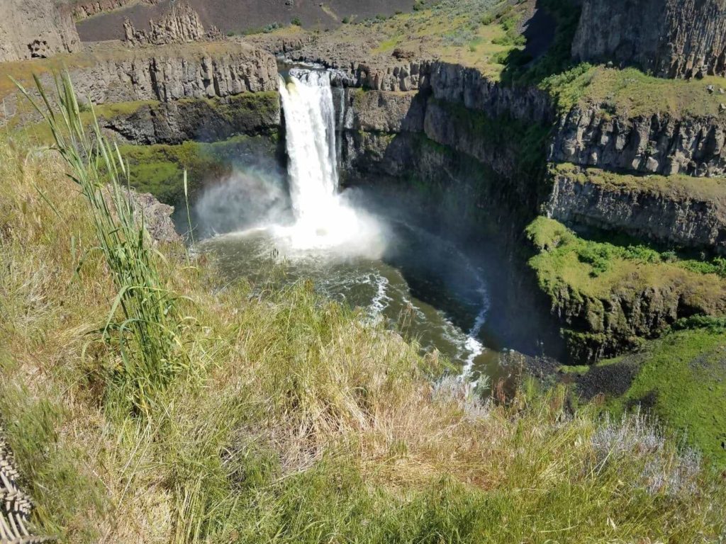
A recessional cataract is a type of falls that keeps moving upstream as the water erodes the cliff, another modern day version of this is Niagara Falls.
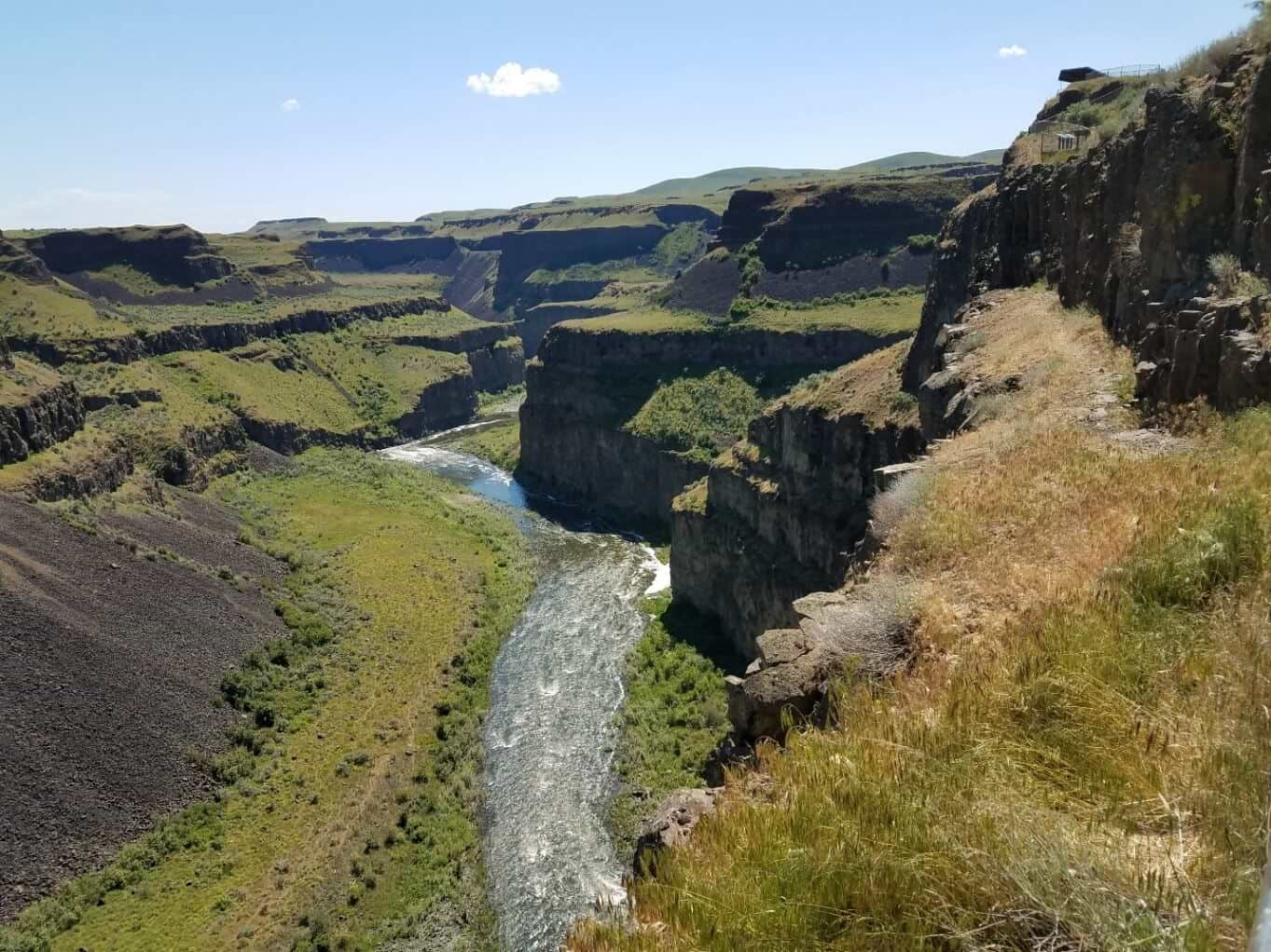
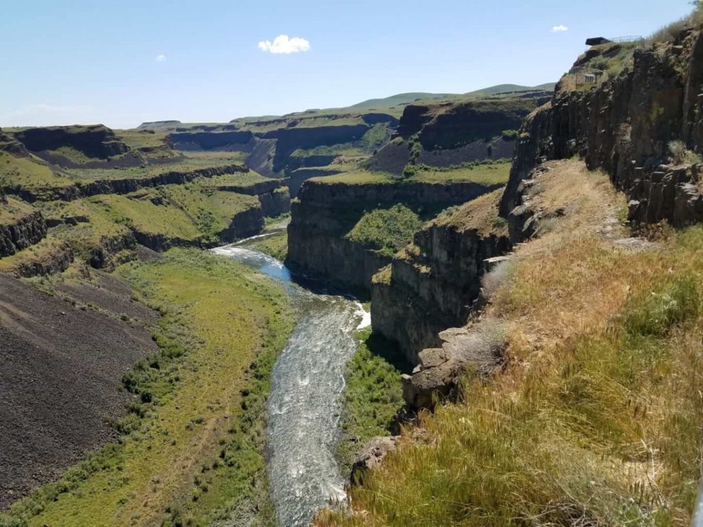
This downstream canyon illustrates the erosional effect of the water over time. Look at the cliffs adjacent to the current falls in the photo above and then visualize the various cliffs shown downstream as once being adjacent to the falls. Obviously, cliff edge erosion has occurred and the slopes are now less abrupt but one can clearly see the progression of the falls over geologic time.
Palouse Falls is somewhat remote and not easily found, at least for me. However, it was worth the trip just to see this and have it so clearly illustrated as to how a “recessional cataract” occurs.
“This was the day that was.”